The Lookbook: Fall Color Hunter 2025
- Ricardo Tejeda

- Dec 11, 2025
- 6 min read
The Lookbook is a photographic journal featuring galleries of our more extensive client work and projects.
For the 2025 autumn season, I was tasked with documenting fall foliage across Western North Carolina for Explore Asheville as part of their annual Fall Color Hunter series. Traveling throughout a number of counties in my region with varying elevation levels, I've amassed a collection of my favorite photos, along with my thoughts on the trails and locations.
Week 1 - October 1 through October 8
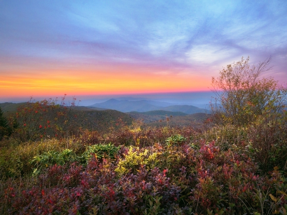
Black Balsam
A favorite since I began nature and landscape photography, my first assignment was Black Balsam. Located in Haywood County, the Black Balsam area sits within the Great Balsam Mountains, a subrange of the Blue Ridge Mountains of Western North Carolina. Black Balsam Knob, one of the more popular peaks, is the second-highest mountain in the Great Balsams, sitting at just over 6,000 feet. This makes the weather extremely hard to predict, and as such, I made it a point to take two separate trips to Black Balsam.
My first visit for the assignment was to capture sunrise. Arriving during the blue hour before sunrise, I trekked through the dark to the top of Balsam Knob. Winds whipping with temperatures in the 30s, I yearned for the secluded comfort of my bed and a deep cup of coffee, but nevertheless, I persevered—not a difficult decision while basking in 360º unimpeded views of some of the most glorious views in the world. Set up atop the peak of Balsam Knob, I remained here for the morning, capturing sunrise as it progressed through golden hour.


Some photos are panoramic images and are best viewed in expanded mode by clicking on the gallery
A few days later, I made my way along the Blue Ridge Parkway, stopping at Bridges Camp Gap Trail to capture images of Yellowstone Prong before returning to Black Balsam to photograph sunset. On my return, I followed the same trail I had before—the Art Loeb Trail—but extended my hike farther into areas I hadn't reached on my prior visit.
Upon reaching my destination, I was greeted with some of the most brilliant displays of cloud formations and light I've ever witnessed at Black Balsam, resulting in some of my favorite photographs I've taken there.


Max Patch
Max Patch has a couple of distinctions in the worlds of outdoor recreation and nature photography. It is one of the most popular spots in all of Western North Carolina. People travel from hours away to have their engagement photos taken at Max Patch. It is so popular, in fact, that if you paid attention during the COVID-19 pandemic, Max Patch gained notoriety as the embodiment of some of the worst traits people can possess, becoming overrun with campers and a dumping ground for the accumulated garbage of the detestable, resulting in restrictions on overnight camping and fires that are still ongoing.
Due to its overwhelming popularity and my desire to capture unique photos, I had never been to Max Patch in my decade-plus of living in Asheville. A crime against landscape photography? Maybe. Years of missed opportunities to enjoy and document one of the most iconic balds of the Blue Ridge Mountains range? Most definitely.
I arrived on a chilly afternoon, immediately finding stunning compositions while still in the parking lot. After a short trek through a dense forest, I spilled out onto the bald and was met with 360º views. To my surprise, I was one of the only photographers capturing the autumn sunset. I spent the evening basking in the magic of Max Patch until nightfall, walking away with my first-ever images of this remarkable location.


Week 2 - October 10 through October 15
Pigeon Gap and Mount Pisgah
Over the years, on my many travels along the Blue Ridge Parkway, I've noted locations I've wanted to photograph that don't sit at overlooks. A small section just south of Pigeon Gap is one such location. On the early, cold morning of October 10, I made my way to Pigeon Gap to photograph that part of the Parkway which overlooks a mountain valley. Arriving during blue hour, I parked and walked a half-mile along the road, coming to the valley that would be my muse for the morning. As the wind whipped and cold dew seeped into my sneakers, soaking my feet, I set up my tripod, dialed in my camera settings, and shot my subject with unwavering determination despite the frigid conditions. My persistence was rewarded, as the morning did not disappoint.
The sun peaked over the horizon. Light fragmented throughout the clear blue sky, painting the landscape in its brilliance. Using the stone guardrail that divides the safety of the Parkway from the unforgiving reality of certain death as a prominent feature that cuts the image in half, I produced a panoramic photo highlighting the Parkway and the views seen from the road. As the minutes passed and the sun rose, light shone down into the valley and illuminated its warmth upon the sleeping wilderness, wispy fog undulating between trees. This produced conditions that resulted in one of my favorite photos from this fall season.


Some photos are panoramic images and are best viewed in expanded mode by clicking on the gallery
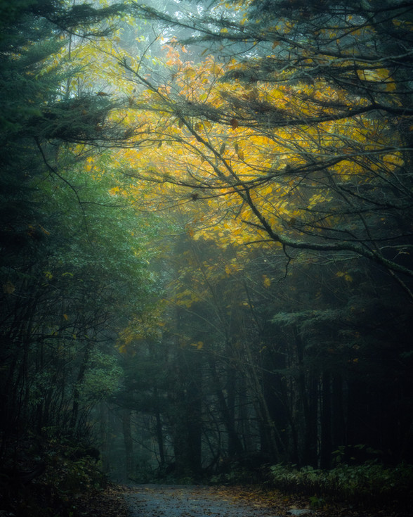
After time well spent capturing sunrise on the Parkway, I drove a short distance to hike the Mount Pisgah trail. Meandering through a lush forest, the start of the trail is relatively easy. The canopy of rhododendron, mountain laurel, and dense woodland shades moss-covered boulders, creating serene compositions. As you continue through the forest, ease gives way to a more strenuous uphill battle as you ascend steep stairways and craggy rocks to the top of the mountain, where a transmission tower and observation deck await.
Views from the observation deck are almost unimpeded, save for the transmission tower blocking a small section. While it's nice to enjoy in person, the vista does not translate into a pleasing image, especially in the late morning and afternoon hours, as the sun crests the sky. On a clear day like the one I was privy to, you can see the Asheville skyline, and I imagine it's lovely during sunrise or sunset.


Pinnacle Park
My last assignment from Explore Asheville was Pinnacle Park. Located in Sylva, research quickly showed this would be a difficult hike. Research did not adequately describe the severity of this the Pinnacle Peak trail. From the parking lot, you begin an immediate and steep uphill climb through a hardwood forest alongside Fisher Creek. The beauty of the forest was sometimes overdshadowed by the grueling and unrelenting trek. After about four miles and 2,400 feet of elevation gain, the forest spits your tired and mangled body out onto a craggy mountaintop overlooking the city of Sylva.
While I did come away with photos that I enjoy, it's my opinion that this trail's ehaustive difficulty isn't worth the view at Pinnacle Peak. As an experienced and avid hiker, I would only recommend this trail to those who are in excellent trail shape, and still, only if you have the masochistic ideation of accomplishment through pain.


Week 3 - October 20 through October 25
Blue Ridge Parkway
At the end of October, after a busy start to the autumn season, I decided to take some personal time to capture my own fall photos. Starting on a northerly direction from Asheville on the Parkway, I made my way to a couple of my favorite locations—Craggy Gardens and the Little Butt trail. Having reopened in late September after a year of being closed due to damage from Hurricane Helene, I was cautiously optimisitc about visiting these treasured icons.
Having stopped at Craggy Pinnacle first, though the forest was passed peak color and bare, there was no noticeable damage from Helene. Making my way to the pinnacle, it was a frigid and blustery morning, with gusts reaching 50mph and making it near impossible to stand still.
After the morning at Craggy Pinnacle, I drove a few miles north to the Little Butt trail. At first appearance, the old growth forest appeared intact. I was quickly disappointed as the woodland I had once known so well looked unrecognizeable at some points. The damage to the local ecosystem was extensive, and truly a sad sight to behold.
A few days later, I drove south on the Blue Ridge Parkway to East Fork Overlook to capture sunrise. One of my favorite destinations for early morning photography, I put my earbuds in, jazz drowning my auditory senses, and was treated to one of the more delightful sunrises of the year. After a few photos of the valley that East Fork overlooks, I walked a half mile on the parkway took a photograph of the Parkway as the sun met the horizon in the distance, creating a starburst. From East Fork Overlook, I drove further south on the Parkway, stopping at Waterrock Knob and other overlooks along the way, and finally making my way to the Great Smoky Mountains National Park, documenting whatever piqued my interests.


Some photos are panoramic images and are best viewed in expanded mode by clicking on the gallery
After not being able to enjoy fall or take place in Explore Asheville's Fall Color Hunter series in 2024 due to Hurricane Helene, it was such a monumentously refreshing opportunity to get outside during this fall season and explore freely. I enjoyed some new locations and captured some of the most magnificent golden hour photos of my career. This was a much needed reminder of what makes the mountains of Western North Carolina so special, and how lucky I am to be able to photograph them for a living.


Comments